


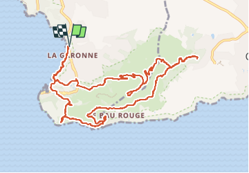
Carqueiranne La Colle Noire Fort de la Bayarde

TOULAUDIN
User


4h41
Difficulty : Medium

FREE GPS app for hiking
 SityTrail
IGN / Geographical institutes
SityTrail Plus
The world is yours!
About
Trail Walking of 14.6 km to be discovered at Provence-Alpes-Côte d'Azur, Var, Le Pradet. This trail is proposed by TOULAUDIN.
Description
très beau parcours ,beaucoup de montées et descentes sur la partie côtière (escaliers), on est souvent sur le rocher, montée à la colle Noire un peu aventurière ça monte raide et dans la végétation, ( il y a peut-être una autre option) randonnée sans difficultées mes soutenue
Positioning
Comments